Blog Archive

Sunday, March 11, 2012

Chapter 10 Ports

Ports

The Port of Los Angeles along with Long Beach is the one of the country's busiest. In 2011 the Port handled over 158 Million Metric Tons (MMRT) of products and goods. To put this into perspective, a metric to weighs 2200 pounds, meaning the Port of Los Angeles moves over 347,600,000,000 pounds of goods a year.


Over 16,000 people are directly employed at the two Ports and it covers over 7,400 acres of land and has a total of 78 miles of waterfront.


The Port is connected by rail and transportation of containers move from the ships to cargo trains for destinations throughout the country.


Port of Los Angeles

In a study released in 2007 on the economic impact of the Ports of Los Angeles and Long Beach collectively done by the Alameda Corridor Transportation Authority (ACTA) found that the Ports as the two largest container velocities are vital to the economic well being of both the state of California and the country as a whole. They handle more than 40% of the nation's total containerized cargo import traffic and 24% of the nation's exports. The trade equates to $256 billion nationally and $62.5 billion of that trade is directly accountable to California. The taxes collected from the Ports is more $6.7 billion annually.


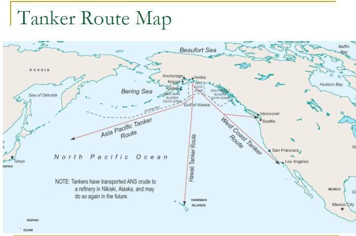
Los Angeles has become the primary gateway for trade between the U.S. and countries of the Pacific Rim. When the the Ports are connected to all the other agglomeration industries it is responsible for more than 900,000 jobs state-wide.


Source:

The Port of Los Angeles
http://www.portoflosangeles.org/                

Chapter 9 Demographics


Demographics

When equating "The Changing South" to Los Angeles the ever shifting mix of cultures and people that share this region demographically came to mind.


With a population estimate of just under 10,000,000 people, L.A. County is by far the largest, Cook County in Illinois comes in second with a population of 5,194, 675.


The table below provide by the U.S. Census Bureau gives a quick reference to the demographic by age and race.


People QuickFactsLos Angeles CountyCalifornia
Population definition and source infoPopulation, 2011 estimateNA37,691,912
Population definition and source infoPopulation, 20109,818,60537,253,956
Population, percent change definition and source infoPopulation, percent change, 2000 to 20103.1%10.0%
Population definition and source infoPopulation, 20009,519,33833,871,648
Persons under 5 years, percent definition and source infoPersons under 5 years, percent, 20106.6%6.8%
Persons under 18 years, percent definition and source infoPersons under 18 years, percent, 201024.5%25.0%
Persons 65 years and over, percent definition and source infoPersons 65 years and over, percent, 201010.9%11.4%
Female persons, percent definition and source infoFemale persons, percent, 201050.7%50.3%
White persons, percent definition and source infoWhite persons, percent, 2010 (a)50.3%57.6%
Black persons, percent definition and source infoBlack persons, percent, 2010 (a)8.7%6.2%
American Indian and Alaska Native persons, percent definition and source infoAmerican Indian and Alaska Native persons, percent, 2010 (a)0.7%1.0%
Asian persons, percent definition and source infoAsian persons, percent, 2010 (a)13.7%13.0%
Native Hawaiian and Other Pacific Islander, percent definition and source infoNative Hawaiian and Other Pacific Islander, percent, 2010 (a)0.3%0.4%
Persons reporting two or more races, percent definition and source infoPersons reporting two or more races, percent, 20104.5%4.9%
Persons of Hispanic or Latino origin, percent definition and source infoPersons of Hispanic or Latino origin, percent, 2010 (b)47.7%37.6%
White persons not Hispanic, percent definition and source infoWhite persons not Hispanic, percent, 201027.8%40.1%


75.9 percent of the population has a High School degree, while only 29 percent hold a Bachelor's or higher. 730,314 students are enrolled in higher education 401,808 being female.


The Catholic church is by-far the largest in terms of people, although the Evangelicals have more congregations.


Religious Affiliation by Religious Body
Los Angeles County


Affiliation
19902000

Congregations

Adherents

Congregations

Adherents
All Religious Bodies
3,536

4,879,355

4,044

5,528,814
Catholic Church
272

3,077,114

278

3,806,377
Orthodox
---

---

46

31,315
Other (see following table)
506

608,113

748

974,062
Protestant Evangelical
1,777

829,693

2,022

587,854
Protestant Mainline
963

355,435

950

339,206
Affiliation of Non-Catholic/Non-Protestant Religious Bodies
Los Angeles County
Religious Body
1990
2000

Congregations

Adherents

Congregations

Adherents
Bahá'í
---

---

44

6,346
Buddhism (estimate)
---

---

145

70,000*
Church of Christ, Scientist
75

---

---

---
Church of Jesus Christ of Latter-day Saints
271

103,286

239

97,347
Hindu (estimate)
---

---

37

70,000*
Jehovah’s Witnessess (estimate)
---

62,400

---

70,000*
Jewish (estimate)
145

501,700

202

564,700
Muslim (estimate)
---

---

48

92,919
Sikh
---

---

14

---
Tao
---

---

4

---
Unitarian Universalist Congregations
15

3,127

13

2,750
Zoroastrian
---

---

2

---

There area total of 1,108 gangs with 85,298 members. According to the California Department of Justice the majority are predominately Latino gangs numbering 53,121 members.


According to the Institute for the Study of Homelessness and Poverty at the Weingart Center, an estimated 254,000 men, women and children experience homelessness in Los Angeles County during some part of the year and approximately 82,000 people are homeless on any given night. 48 percent graduated high school and 32 percent have a bachelors degree or higher. Over a quarter of the homeless have some type of mental illness. African Americans make-up approximately half of the homeless population in L.A. County and yet they only make-up just under 9 percent of the overall population. 25 percent of all the children living on the streets were either physically of sexually abused.


There are over 4 million registered voters in L.A. County with 2,286, 987 being Democrats, which make-up 51.40 percent of the electorate, 1,049,383 or 23.58 percent are Republicans.    


Sources:

Los Angeles Almanac
http://www.laalmanac.com/default.htm


Chapter 8 Varied Topography


Varied Topography

When explaining the topography of Los Angeles one just has to turn on the local news and watch the weather report. They usually have three different reports for these micro-climates, the deserts and mountains, valleys and foot hills, and finally the coast, although it could be broken up into five distinct micro-climates when adding the high and low deserts.


The varied topography dictates these climates and there are times in the summer when it is 65 degrees on the coast and it is 110 in the desert.


Beach photography, turquoise blue sky, sand and surf, nautical decor, Malibu lifeguard tower, California print 8x12 Oht


The coast is tempered by the Pacific Ocean and the swings in temperature are usually very small. The average temperatures are around 61 to 65 degrees

The valley's can fluctuate some 30 degrees from 85 in the heat of the day to 55 as a low at night. The average temperature ranges between 63 to 67 degrees, although in the summer months, especially in late August and early September temperatures can reach well into the triple digits and days of 100 degree plus are common. In the winter the temperature can drop into the 30s at night.


In the the San Gabriel Mountains, which are only 25 to 50 miles away from the ocean and rise to their highest point at Mount San Antonio (Mt Baldly) at 10,064 feet.


The average temperature can fluctuate from the 30s to mid 40s in winter and exceed 90 degrees in the peak summer months.


Antelope Valley California

The High Desert the average daily temperature is 61 degrees and this has allot to do with its elevation, which ranges between 2,500 to 3,975 feet above sea level. The average daily temperature from July to August is 94 degrees, while in winter the daily average high is right around 62 degrees and lows can reach into the 20s and occasionally lower at night.


The Low Desert  has the most extreme temperatures and climate. Geographically, this region consist of the portions of the Colorado, Sonoran, and Yuha Deserts and because it is in the rain shadow of the traverse and peninsula ranges of Southern California the amount of rain received by this region is less than 5 inches a year.  The winter months are warm and mild with highs between 73 and 86 degrees, while summers can feel as though Satan himself was on vacation there with temperatures eclipsing 120 degrees on a regular basis.


Sources:

Mt. Baldy-Wrightwood, California
http://www.city-data.com/city/Wrightwood-California.html

The Weather Channel
http://www.weather.com/outlook/recreation/outdoors/wxclimatology/monthly/graph/USCA1263

NOAA
http://graphical.weather.gov/sectors/southcalifornia.php


Chapter 7 Rugged Land

Rugged Land

 To equate the region of Los Angeles to that of the Bypass East is tough at first until one starts to look at the ruggedness of the terrain both reside in. The mountains that surround the L.A. Basin are just as rugged as the coastline of Maine, the terrain is different, although it is a rugged land.  To the right are the snow capped San Gabriel Mountains.


Many of the peaks reach over 9,000 feet with highest at 10,064 called Mount San Antonio (Mt. Baldy).


On the backside of the San Gabriel Mountains to the North and East is the vastness of the Mojave desert and the Antelope Valley.


The  Mojave covers over 54,000 square miles and it's topography is typically related to the Basin Range.


Many parts of the Mojave typically range from highs of around 95-105F in the summer to lows of around 20-30F in the winter.The Mojave Desert receives less than 6 inches of rain a year and is generally between 3,000 and 6,000 feet in elevation. 
Los Angeles From Space
Essentially, Los Angeles is surrounded by high Mountains, a huge desert to the East, and the vastness of the Pacific Ocean to South and West. This isolates Los Angeles from the rest of the country and because of its geographic location it almost seems like its is an island.  


Sources:


National Parks Service, U.S. Department of the Interior, Mojave
     http://www.nps.gov/moja/index.htm