Friday, May 4, 2012
Chapter 18 "Surf"
 |
| Sally Fields as Giget |
 |
| Countyline |

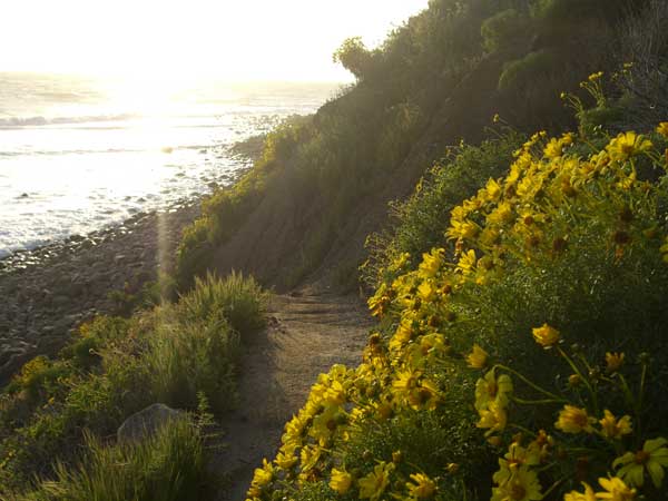 |
| Staircase |
Just south of countyline is a place surfers call Staircase. This is a beach and reef break that gets its name from the steep winding path one takes from the dirt parking lot just off PCH.
 |
| Leo Carrillo |
Leo Carrillo "Secos," is next in line. This pointbreak works well with a south, southwest, and west swell , the best tides for surfing are Mid to High. Only one take off spot and gets crowded in the summer with long boarders.

A beach kinda hidden away just off PCH called Nicholas Canyon (Aka Zero's in Surf lingo) is our next stop. The surf spot is a left hander, meaning when one is looking at the wave from the beach it breaks from left to right.
 |
| Zuma |
Zuma, where the Valley goes when the temperatures hit the triple digits. There is plenty of parking and a huge beach that stretches a for miles. Be careful when the waves are big because the rip tides are vicious, plenty of rescues are done by lifeguards when novices run into the water and get swept out to sea. Zuma could mean one or two things in the Chumash language, the first would be "Four Winds," and second is "Abundance."
 |
| Looking at Little Dume |
Just pass Zuma is Point Dume, there are two spots to surf called Big Dume and Little Dume. Both break off points from right to left and are really fun when it's big. When a hurricane hits the window off of Baja is the best time to go. Before going out watch the break because it gets a little dangerous on a lower tide because of the shallowness and the huge rocks that protrude out of the water and under the break.
 |
| Latigo |
Latigo Canyon is a mellow right point break that can get pretty good with the right swell direction. Park on the PCH. Access is a little tricky due to the fact that Latigo Shore Drive is private.
 |
| Malibu on a Big Day |
What some would call the premier surf spot and most iconic surfing beach in Southern California is Malibu. This wave breaks from left to right off of three different points, 1st point is primarily for long borders, 2nd is where one surfs when the crowds are two large at the 3rd point, and 3rd is the best spot to surf and on a large day and the waves occasional connect from 3rds all the way through 1st. Water can be dirty after a storm and it is best to stay away because the lagoon dumps right out into the line-up.

Topanga is a really crowded spot and their is allot of free parking along with a parking lot where you will pay $5 to park. Across the street is the Reel Inn where you can get fresh seafood. The menu prices have gone up in recent
years and the price for beer is $4 and the average plate is somewhere around $16.
-1.JPG) |
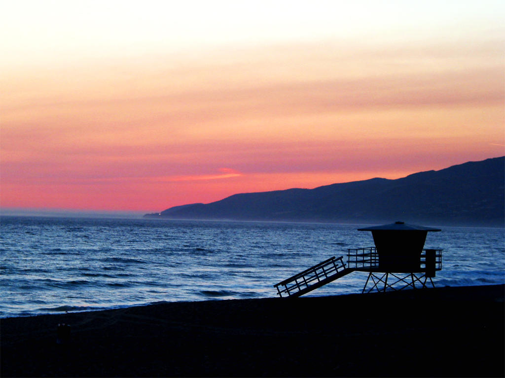
| Sunset |
Where Sunset Boulevard ends and gets its name is ironically enough the spot called Sunset. Sunset is right off of PCH and the traffic speeds by as if there was no beach there at all. It is a great place for beginners and if one wants to learn to surf this would be the place.
 |
| Redondo Beach |
After Sunset are the urban beaches of Santa Monica, Venice, El Segundo, Manhattan, Hermosa, and Redondo Beach. These are all beach breaks and can get good from time to time. This is where you go to ride bikes, roller blade, and one can often hear a college girl from Loyola randomly yelling, "Whooooo!"
 Haggerty's, this is a performance wave. Take your longboards over to the cove. Probably the best-shaped wave in the PV area, Haggerty's takes all north and west swells from 3 to 15 feet and grooms them into a classic left point/reef with three takeoff zones. Lower Haggerty's, Hags, and Upper Haggerty's make up the takeoff spots and this place is always crowded and full of hazards, which include slippery trails, silly locals from Torrance and the rich in PV, car vandalism, and the local PVE police often side with their boys that live in the area. This place is for advanced surfers only and can get pretty dangerous, not only with the mobs of disgruntle surf punks from the South Bay, the wave when it is big can teach a newcomer the lesson of respect.
 |
| Lunada Bay |

We will end our journey at Cabrillo Beach in San Pedro. This is more of a family beach and less for surfing, although it is a good place to splash around and paddle out on a sponge board for a beginner if the waves are small. Also being so close to the Harbor tends to lead to dirty, dirty, water.
Sources:
Surfline
http://www.surfline.com/home/index.cfm
L.A. Times
Tuesday, May 1, 2012
Chapter 16 "Ring Of Fire"
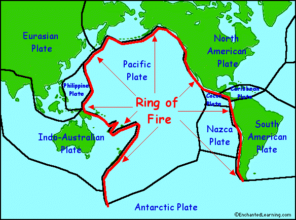
Los Angeles, like the North Pacific Coast sits on top of a of active fault lines and these faults are interconnected in what is called, "The Ring of Fire." It is an area where large numbers of earthquakes and volcanic eruptions occur. About 90 percent of the worlds earthquakes occur around this ring and they are a direct result of plate tectonics.

In Southern California about 30 earthquake a day occur with most of of a magnitude 2.0 or less.The Richter Magnitude Scale, more commonly used by the media and the public, measures the magnitude of the earthquake. It is calculated logarithmically in which each unit of amplitude of earthquake waves is factored ten times larger than the previous reading. An earthquake measured at 8.0, for example, would be 10,000 times stronger than an earthquake measured at 4.0. Great earthquakes, such as the 1964 Good Friday earthquake in Alaska, have magnitudes of 8.0 or higher. On the average, one earthquake of such size occurs somewhere in the world each year. The Richter Scale has no upper limit. Recently, another scale called the moment magnitude scale has been devised for more precise study of great earthquakes.
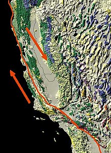
 The San Andreas fault is considered one of the most dangerous in
Southern California, partly because it has been some time since it has moved and its southern
section is capable of producing a temblor as large as magnitude 8.1. or greater.
The San Andreas fault is considered one of the most dangerous in
Southern California, partly because it has been some time since it has moved and its southern
section is capable of producing a temblor as large as magnitude 8.1. or greater. Earthquake experts consider 1994's destructive 6.7-magnitude Northridge quake, which occurred on a different fault, to be a medium-sized quake.

There are over 60 known large faults in L.A. County with an untold number of blind and smaller faults.

There is no such thing as “earthquake weather”. Statistically, there is an equal distribution of earthquakes in cold weather, hot weather, rainy weather, etc. Furthermore, there is no physical way that the weather could affect the forces several miles beneath the surface of the earth. The changes in barometric pressure in the atmosphere are very small compared to the forces in the crust, and the effect of the barometric pressure does not reach beneath the soil.
 |
| Los Angeles Star 1857 |
Sources:
Los Angeles Geology
http://www.scvresources.com/geology/
USGS
http://earthquake.usgs.gov/earthquakes/recenteqscanv/FaultMaps/Los_Angeles.html
Fort Tejon Earthquake
http://www.rms.com/publications/1857_FortTejon_EQ.pdf
Chapter 15 California "Streets and Freeways"

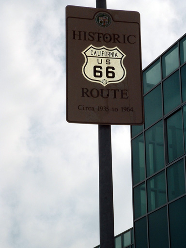
Conventional highway can vary from two to eight lanes, although they usually top out at four and they have all the characteristics of normal streets with stop signs, signals, and access to business and residential areas. An example of a conventional highway in Los Angeles would be Route 66 as runs down Santa Monica Boulevard.

The first freeway in Los Angeles was the Arroyo Seco Parkway and connected Pasedena with downtown Los Angeles and it opened in 1940.

The longest street in Los Angeles is Sepulveda Boulevard which runs through Los Angeles county from the San Fernando Valley to Long Beach and is 76 miles long.
The shortest street in Los Angeles is Powers Street in downtown and runs a total of 13 feet.
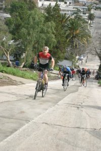
The steepest street is in Silver Lake called Fargo Street and it has a grade of 32 percent.

All even numbered highways and freeways run east-west, while odd run north-south. Of course there are exceptions, the 14 seems to run due north through Palmdale.

In 2008 there was about 6 million licensed drivers in L.A. County and the average commute time is 29.5 minutes one way.
 |
| Loyd |
During the 1940s, the LAPD began alerting radio reporter Loyd Sigmond whenever a major automobile accident occurred on city streets. These notices became known as "SigAlerts," and were later issued to alert all local media. The term"SigAlert"eventually came to apply to any incident on greater Los Angeles area freeways which block two or more lanes of traffic for two or more hours.
Sources:
California Dept. of Transportation (Caltrans)
Los Angeles A to Z by Leonard & Dale Pitt
SigAlert!
http://www.snowcrest.net/marnells/sigalert.htm
Chapter 14 Borderlands
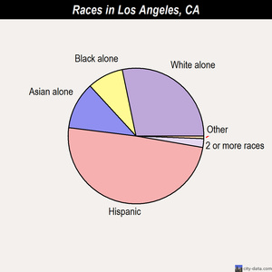
Los Angeles is directly part of the Southwest border area and has the largest Mexican population outside of Mexico City. According to the Los Angeles County 2000 Census, Hispanic's number more than 4 million people and make up almost 50 percent of the total population.

Culturally, the Spanish and Mexican influence can be seen in the different names of different geographic areas in the city. Hacienda Heights means "farm estate," La Brea "tar," Altadena, literally means "Upper Dena,"Toluca Lake, which was derived from an Aztec name, and El Sereno meaning "serene," and the list goes on and on, all one needs to do is jump in the car and drive through the city and what becomes apparent is the cities latin history.
 Another influence on the culture of Los Angeles is the food. From every region in Mexico the food inundate the culture as a whole. The styles were taken from Sinaloa, the Yucantan, Oaxaca, Sonora and as each immigrant from the south entered the city they brought a different method and style that seeped into the community and changed what was once bread into a tortilla.
  |
| Opening Day 1939 |
Los Angeles has always had a connection with its southern neighbor Mexico, and at one time was part of that same country up until the Mexican-American War, which ended with American annexation and California becoming a state in 1850. From 1850 to the early 1980's the city was predominately Anglo, although through immigration and birthrate the city is far more Hispanic in nature and has more commonalities with the countries to the south than it does with the states of the east coast. An example of this would be seen in the architecture where many early migrants entered Los Angeles at Union Station, which is designed in the Mission Revival style. Union Station took the place of La Grande Station and opened in 1939. The station reflects the cities origins and connects us to the Spanish and Mexican past.
Sources:
Los Angeles Almanac
U.S. Census Bureau
KCET, Union Station
Chapter 13 "Native Wildlife"
 Coyotes are by far the most numerous of the large carnivores that continue to live within the city and it is believed
that more than 5,000 coyotes roam the City of Los Angeles. Thousands more live
throughout the county. Mostly, these animals live in foothills in and around the
city. Coyotes are highly intelligent adaptable and possess excellent sensory
abilities. Urbanized coyotes can survive on a variety of foods including
garbage, feeding by people, food left out for pets and small pets themselves.
Coyotes are by far the most numerous of the large carnivores that continue to live within the city and it is believed
that more than 5,000 coyotes roam the City of Los Angeles. Thousands more live
throughout the county. Mostly, these animals live in foothills in and around the
city. Coyotes are highly intelligent adaptable and possess excellent sensory
abilities. Urbanized coyotes can survive on a variety of foods including
garbage, feeding by people, food left out for pets and small pets themselves. By the 1940s, mountain lions were thought to have been eradicated from Los
Angeles. Now, naturalists estimate that about a dozen mountain lions live in the mountainous areas of Beverly Hills, Studio City, Tarzana, and Chatsworth.
As recently as 2004, a mountain lion was seen prowling Griffith Park, believed
to have arrived there via urban water channels. These big cats hunt at night and prey on small game, deer, and, on occasion, unfortunate stray pets.
Mountain lions have attacked and, in fact, killed bicyclists, hikers and runners
in Southern California. The only verified mountain lion attack (according to the
California Department of Fish and Game) on a human in Los Angeles County was a
non-fatal attack on a 27-year-old adult male on Mount Lowe in the San Gabriel
Mountains in March 1995. Nevertheless, two cyclists were attacked in January 2004 by a mountain lion in a regional park in nearby Orange County,
one fatally.
By the 1940s, mountain lions were thought to have been eradicated from Los
Angeles. Now, naturalists estimate that about a dozen mountain lions live in the mountainous areas of Beverly Hills, Studio City, Tarzana, and Chatsworth.
As recently as 2004, a mountain lion was seen prowling Griffith Park, believed
to have arrived there via urban water channels. These big cats hunt at night and prey on small game, deer, and, on occasion, unfortunate stray pets.
Mountain lions have attacked and, in fact, killed bicyclists, hikers and runners
in Southern California. The only verified mountain lion attack (according to the
California Department of Fish and Game) on a human in Los Angeles County was a
non-fatal attack on a 27-year-old adult male on Mount Lowe in the San Gabriel
Mountains in March 1995. Nevertheless, two cyclists were attacked in January 2004 by a mountain lion in a regional park in nearby Orange County,
one fatally. At
one time, Grizzly Bears roamed widely throughout
Los Angeles County and Southern California. Hunting,
however, decimated the numbers of this. In 1916, the last known Grizzly in Southern California was shot
and killed in Los Angeles County. Grizzlies, whose image appears on California's
state flag, are now extinct in California. By 1933, bears of any sort were already
extinct in the mountains of
Southern California. That year, in an attempt to
reintroduce bears to the Los Angeles area, rangers from Yosemite
National Park introduced 11 California Black Bears
to the San Gabriel Mountains near Crystal Lake. The Black Bear is a smaller and much less
aggressive cousin of the Grizzly. Biologists estimate that
about 150 to 500 Black Bears now roam Angeles
National Forest.
At
one time, Grizzly Bears roamed widely throughout
Los Angeles County and Southern California. Hunting,
however, decimated the numbers of this. In 1916, the last known Grizzly in Southern California was shot
and killed in Los Angeles County. Grizzlies, whose image appears on California's
state flag, are now extinct in California. By 1933, bears of any sort were already
extinct in the mountains of
Southern California. That year, in an attempt to
reintroduce bears to the Los Angeles area, rangers from Yosemite
National Park introduced 11 California Black Bears
to the San Gabriel Mountains near Crystal Lake. The Black Bear is a smaller and much less
aggressive cousin of the Grizzly. Biologists estimate that
about 150 to 500 Black Bears now roam Angeles
National Forest.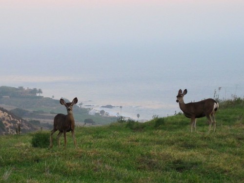 |
| Mule Deer in Malibu |
The regions only native deer species is called the mule deer and it can be found in all the mountains and wild-lands within and surrounding the city. They are common in the Hollywood hills, Santa Monica Mountains and there numbers throughout the county are estimated in the thousands.
 There is a marine species called Grunions and they are native only to the
shores of Southern California, they are the only known fish to lay its eggs on land. Between March and August, they come onshore in
large numbers to lay eggs and bury them in the sand. The sand protects the
eggs for up to nine days until ready to hatch. It is legal to catch
grunions while they are on the beach, but only with bare hands.
There is a marine species called Grunions and they are native only to the
shores of Southern California, they are the only known fish to lay its eggs on land. Between March and August, they come onshore in
large numbers to lay eggs and bury them in the sand. The sand protects the
eggs for up to nine days until ready to hatch. It is legal to catch
grunions while they are on the beach, but only with bare hands. 
Of-course there are numerous amounts of different animal species native to Los Angeles and the list could cover well into the hundreds, although the most numerous is probably a city dweller and a rodent that goes by the name "Rat."
Sources:
L.A. Almanac
Chapter 12 Vegetation
 |
| California Kelp Forest. |
 |
| Coastal Sage and Chaparral |
 |
| lemonade-berry |
If one was to strip away the urban development within the basin the most common type of vegetation would be Coastal Sage and Chaparral. It grows in the canyons and Mountains of the Traverse Ranges and coastal sage scrub is a diverse and globally rare habitat type occurring on the terraces and foothills below 3, 000 feet.
This habitat type is characterized by low, a
romatic and drought-resistant shrublands of black sage (Salvia mellifera), white sage (Salvia apiana), Munz’s sage (Salvia munzii), California sage (Artemisia californica), California buckwheat (Eriogonum fasciculatum), bush sunflower (Encelia californica), toyon (Heteromeles arbutifolia), lemonade-berry (Rhus integrifolia), and countless other shubs.
 |
| California buckwheat |
All chaparral communities are adapted to fire. Some of the species crown spout, meaning they re-grow from root after fire. Others shed seeds which will only grow after fire. Fire plays an important role in most of the plant communities of Southern California, especially in those with high amounts sage and chaparral.

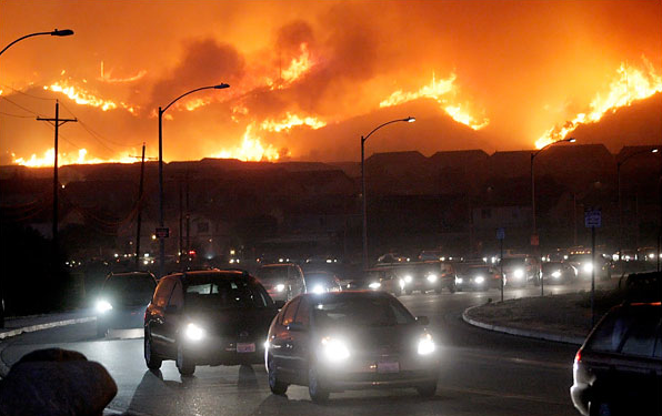
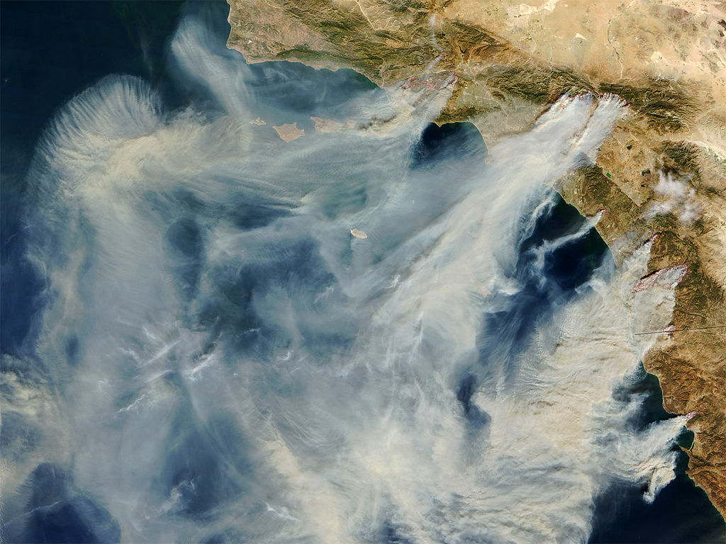
On average these areas burn every 15 to 20 years and these drought-resistant plants contain a huge amount of fuel, which lead to high heat fires that burst some of these plants into flames as the fire approaches. These wildfires usually happen after drought in late summer and early fall and they are pushed by the high pressure systems that park over the great basin, which pushes winds from the deserts down through the canyons warming them as they move out towards the Pacific. These winds are known as the Santa Ana's and they are the motor that pushes the famous fires that inundate the mountains and canyons, while the plant life is the fuel.
 |
| California Oak |
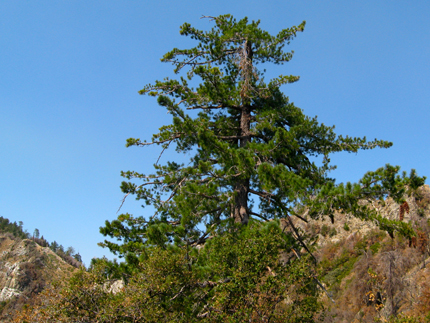
The type of trees native to the Los Angeles region are California Oaks, Sycamores, and broadleaf conifers. They are interspersed in the interior valley's, canyon's, and throughout the Coast, Traverse, and Peninsular Ranges.
 |
| Sugar Pine |
Moving into the higher elevation the native trees consist of eight different types pines. They include the Sugar, Jeffrey, Coulter, Ponderosa. Pinyon, Lodgepole, Gray, and Limber. They grow between 2,000 and 9,000 feet in elevation and are found in different areas of the San Gabriel and surrounding Mountain Ranges.
 |
| Joshua trees |
Dropping out of the higher elevations into the Antelope Valley the vegetation changes once more and one would find Joshua trees, dry oak, California scrub, and in spring flowers such as the California poppy and silver lupine.
 |
| California Poppy |
Sources:
http://digital-desert.com/antelope-valley/
San Gabriel Mountains, Plant Communities
http://tchester.org/sgm/plants/communities/index.html
http://www.fire.ca.gov/
http://www.eoearth.org/article/California_coastal_sage_and_chaparral
Subscribe to:
Posts (Atom)