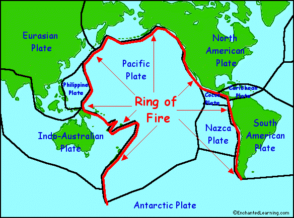
Los Angeles, like the North Pacific Coast sits on top of a of active fault lines and these faults are interconnected in what is called, "The Ring of Fire." It is an area where large numbers of earthquakes and volcanic eruptions occur. About 90 percent of the worlds earthquakes occur around this ring and they are a direct result of plate tectonics.

In Southern California about 30 earthquake a day occur with most of of a magnitude 2.0 or less.The Richter Magnitude Scale, more commonly used by the media and the public, measures the magnitude of the earthquake. It is calculated logarithmically in which each unit of amplitude of earthquake waves is factored ten times larger than the previous reading. An earthquake measured at 8.0, for example, would be 10,000 times stronger than an earthquake measured at 4.0. Great earthquakes, such as the 1964 Good Friday earthquake in Alaska, have magnitudes of 8.0 or higher. On the average, one earthquake of such size occurs somewhere in the world each year. The Richter Scale has no upper limit. Recently, another scale called the moment magnitude scale has been devised for more precise study of great earthquakes.
 The San Andreas fault is considered one of the most dangerous in
Southern California, partly because it has been some time since it has moved and its southern
section is capable of producing a temblor as large as magnitude 8.1. or greater.
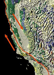
The San Andreas fault is considered one of the most dangerous in
Southern California, partly because it has been some time since it has moved and its southern
section is capable of producing a temblor as large as magnitude 8.1. or greater. Earthquake experts consider 1994's destructive 6.7-magnitude Northridge quake, which occurred on a different fault, to be a medium-sized quake.

There are over 60 known large faults in L.A. County with an untold number of blind and smaller faults.

There is no such thing as “earthquake weather”. Statistically, there is an equal distribution of earthquakes in cold weather, hot weather, rainy weather, etc. Furthermore, there is no physical way that the weather could affect the forces several miles beneath the surface of the earth. The changes in barometric pressure in the atmosphere are very small compared to the forces in the crust, and the effect of the barometric pressure does not reach beneath the soil.
 |
| Los Angeles Star 1857 |
Sources:
Los Angeles Geology
http://www.scvresources.com/geology/
USGS
http://earthquake.usgs.gov/earthquakes/recenteqscanv/FaultMaps/Los_Angeles.html
Fort Tejon Earthquake
http://www.rms.com/publications/1857_FortTejon_EQ.pdf
No comments:
Post a Comment